Award-winning guidebook writer and photographer Vivienne Crow knows some of the best places to see the woods changing colour, the fells taking on new hues and the wildlife preparing for winter.
She’s come up with a list of some of her favourite walks, all accessible by Stagecoach bus.
There are routes here to suit all abilities.
If you’re thinking of tackling one of the fell walks suggested though, check out the Adventure Smart website for advice.
And don’t forget a head torch, it gets dark early this time of year.
For bus times, go to the Stagecoach website or download the Stagecoach Bus app from Google Play or Apple’s App Store.
Pensioners travel free with a NoW card while everyone else pays only £3 per journey under the national fare-cap scheme.
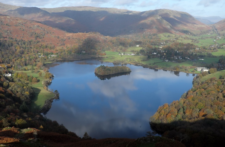
Walk 1: Loughrigg Fell
Bus route: 555, 599, 516 and 505 to Ambleside
Length/ difficulty: 6¼ miles; moderate; approximately 3½ hours
Map: Ordnance Survey OL7, English Lakes SE
Despite its relatively modest height, Loughrigg (1,099ft/335m) provides walkers with some great all-round views. Langdale, the Helvellyn range, the Coniston mountains and Windermere are all visible from this bracken-covered top.
Starting from Ambleside, head towards Pelter Bridge and then the Rydal Caves, high above Rydal Water. Continuing to Loughrigg Terrace, there are plenty of benches from which to enjoy the dark waters of Grasmere below and the colourful canopy of Penny Rock Wood.
Having rested, it’s time for the climb up a steep, constructed stairway leading almost directly to the summit trig pillar.
From here, there are a multitude of paths from which to choose; you could spend hours exploring this standalone fell, safe in the knowledge that you’re unlikely to stray too far from the start point.
Probably the best-known route is to follow trails south-east, dropping on to a well-used bridleway that descends to Miller Brow and back to the River Rothay.
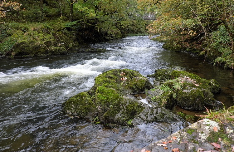
Walk 2: Langdale Waterfalls
Bus route: 516 to Elterwater
Length/ difficulty: 7¼ miles; easy/moderate; approximately 3¼ hours
Map: Ordnance Survey OL7, English Lakes SE
Is this one of the best low-level walks in the Lake District? It’ll definitely feel like it on a clear, crisp autumn day.
Starting from Elterwater in Great Langdale, the route crosses to the neighbouring valley of Little Langdale to pick up a little used path along the base of Lingmoor Fell.
With several ups and downs and a little bit of rough ground underfoot, this is the only part of the entire day that could be classed as anything but ‘easy’.
The bit of extra effort required is amply rewarded with stunning views across Little Langdale Tarn towards Wetherlam and Swirl How.
Stony tracks and quiet lanes then lead east towards the woods surrounding Colwith Force and Skelwith Force, two waterfalls that look particularly impressive after autumn deluges.
The return stroll beside the River Brathay and Elter Water, with its excellent views of the Langdale Pikes, is the perfect way to end a perfect day.
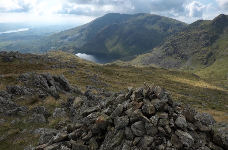
Walk 3: Wetherlam
Bus route: 505 to Coniston
Length/ difficulty: 6½ miles; moderate/hard; approximately 4¼ hours
Map: Ordnance Survey OL6, English Lakes SW
This walk comes with a warning: it’s far too short and will leave you craving more.
It approaches the 2,503ft (763m) summit of Wetherlam from Coniston, first exploring the disused mine workings of Red Dell before heading along Black Sails’ south ridge.
This excellent spur sees little foot traffic and yet there is a grassy trail all the way along it, making light work of the mile-long climb. From Black Sails (2,444ft/745m), there’s a short, easy pull to the top of Wetherlam.
Once you can drag yourself away from the summit vista, which takes in the high fells ringing Eskdale as well as the Langdale Pikes, the Helvellyn range and Blencathra to name just a few, the return route heads south along the Lad Stones ridge, making for another thoroughly enjoyable, and relatively quiet, amble along the apex of the high ground.
Back in Coniston after the walk, there are several pubs and cafés to choose from while you wait for your bus back.
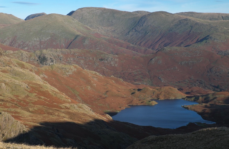
Walk 4: Sergeant Man via Easedale
Bus route: 555 and 559 to Grasmere
Length/ difficulty: 8½ miles; hard; approximately 5¼ hours
Map: Ordnance Survey OL6, English Lakes SW and OL7, English Lakes SE
The poet Wordsworth once likened the Lake District valleys to spokes on a wheel. If you can imagine such a wheel, Sergeant Man would be close to its hub, the centre of the great geological dome from which the dales radiate.
Thanks to this special position within the National Park, when you stand on its summit, no matter which way you look, it seems like there’s nothing but hills as far as the eye can see.
Climbing the fell from Grasmere, the best approach is via Easedale Tarn and then Blea Rigg.
With the path swinging from one side of the ridge to the other, walkers are treated to magnificent views of the Langdale Pikes one minute and then glimpses of the Fairfield and Helvellyn ranges the next.
Beyond Sergeant Man, little-used trails descend the Tarn Crag ridge, home to the third Wainwright of the day, before dropping into Far Easedale for a gentle finale.
Back in the valley, watch for red squirrels, particularly busy in autumn as they store up food for winter.
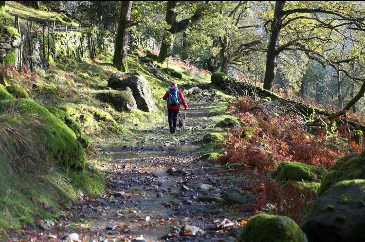
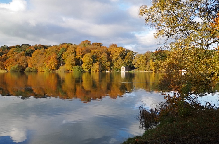
Walk 5: Borrowdale’s woods
Bus route: 77/77A (until November 2) and 78 to Seatoller
Length/ difficulty: 4¾ miles; easy/moderate; approximately 2½ hours
Map: Ordnance Survey OL4, English Lakes NW
The national importance of Borrowdale’s Atlantic oakwoods was recognised last year when the valley became one of the first in the new King’s Series of National Nature Reserves.
But it’s not just oak that cloaks the rugged sides of this beautiful valley; birch, ash, yew, larch and wild cherry are among the many other species found here, each contributing a different hue to autumn’s arboreal kaleidoscope.
A great way to experience Borrowdale is to catch a bus from Keswick right through the valley to Seatoller. Having enjoyed the vibrant display through the windows of the bus, you can then enjoy it at a more leisurely pace by heading east and then north through ancient woods beside the River Derwent.
After skirting the base of Castle Crag, dipping in and out of old slate quarry workings along the way, return via a slightly higher path that provides a fresh perspective on the scenery through which you’ve just passed.
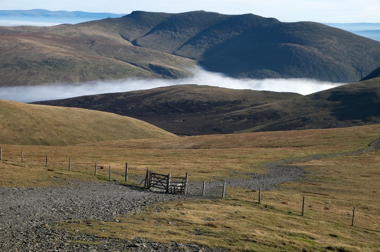
Walk 6: Skiddaw
Bus route: 553, 509, 554, 555, 78 and X4/X5 (plus the 77/77A, 509, 553 until November 2) to Keswick
Length/ difficulty: 12½ miles; hard; approximately 7 hours
Map: Ordnance Survey OL4, English Lakes NW
England’s fourth highest mountain dominates the town of Keswick. If you’re exploring the area – enjoying Borrowdale’s woods, strolling by the shores of Derwentwater or just calling in at Castlerigg Stone Circle – it’s hard to ignore the siren call of Skiddaw.
This 3,054ft (931m) mountain can be climbed directly from the town centre. After following a popular route up on to the northern flanks of Latrigg, the constructed path up Jenkin Hill makes for a straightforward climb to the top.
It’d be hard to get lost and you won’t encounter bare rock or other obstacles; you will, however, encounter lots of other walkers.
For a quieter return route, drop to Skiddaw House via Sale How, enjoying great views of the ‘back’ of Blencathra on the way down; then join the superb balcony path through the Glenderaterra gap between the Skiddaw massif and Blencathra.
After all that hard work, you’ll be needing to refuel and Keswick offers everything from fish and chips to fine dining.
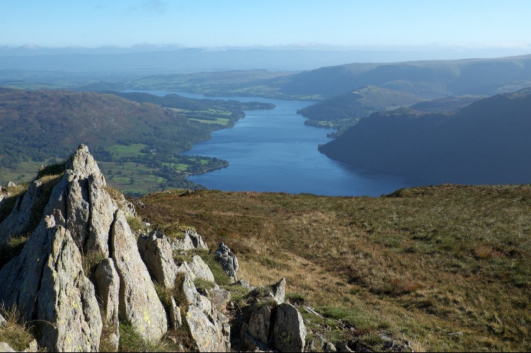
Walk 7: Sheffield Pike
Bus route: 508 and 509 to Glencoyne (509 until November 2)
Length/ difficulty: 6¼ miles; moderate/hard; approximately 3¾ hours
Map: Ordnance Survey OL5, English Lakes NE
Sheffield Pike is often forsaken by walkers in favour of higher, more famous peaks in the Helvellyn group.
However, it is well worth a visit in its own right – both for its atmospheric setting and its superb views of Ullswater and those neighbouring summits.
This is a relatively straightforward ‘up-and-down’ walk. Ask the bus driver to drop you at Glencoyne beside Ullswater.
From here, the route heads up past Glencoyne Farm and then along the northern slopes of Sheffield Pike to enter the higher reaches of this gorgeous side valley.
There’s some bog-trotting to contend with but it’s short-lived and you’re soon standing on the summit looking east towards Ullswater and, in the distance, the North Pennines.
As you begin the descent, it’s the rugged Helvellyn that dominates the outlook.
Drop through disused mine workings and a juniper forest to the valley of Glenridding Beck and then end your outing with an easy stroll along the lightly wooded shores of Ullswater.
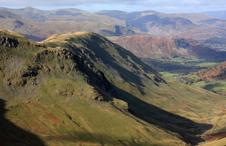
Walk 8: Hartsop Dodd and Gray Crag
Bus route: 508 to Hartsop (until November 2)
Length/ difficulty: 6 miles; hard; approximately 4½ hours
Map: Ordnance Survey OL5, English Lakes NE
Hartsop Dodd and Gray Crag rise obstinately skyward on either side of Pasture Beck, linked by the rocky saddle of Threshthwaite.
Many walkers are probably put off climbing these fells as soon as they pick up a map and home in on the Hartsop area: those contour lines do look uncomfortably close together, don’t they?
And yet what could be better, in just six miles, than the combination of striding out along two superb, grassy ridges – with just the ravens for company – and clambering across the slightly more challenging gap that separates them?
An added bonus comes in the form of a sound that drifts eerily across the eastern Lake District fells at this time of the year – the bellowing of red deer stags involved in the annual rut.
You’ll have to be quick though, this walk takes advantage of the 508 bus’s seasonal extension to Windermere.
After November 2, the bus terminates at Patterdale, which is two miles from the start of the walk in Hartsop.
Walk 9: Talkin Tarn from Brampton
Bus route: 685 to Brampton
Length/ difficulty: 6¼ miles; easy; approximately 2¾ hours
Map: Ordnance Survey Explorer 315, Carlisle
Almost everyone who lives in north-east Cumbria knows and loves Talkin Tarn, but very few people are aware that walking to this popular beauty spot from the nearby market town of Brampton is a joy in itself.
Using quiet lanes and the bed of a disused railway, it heads south-east from the town, skirting the edge of Rowbank Wood to reach the tarn, a stone’s throw from the foot of the North Pennines.
A waterside café is open all year round if you fancy a warming coffee before completing a slow, gentle circuit of the tarn. More country roads and a network of superb paths and tracks then lead back to Brampton – and all the while, you’re kicking your way through the fallen leaves of oak, sycamore and beech trees.
If you enjoy birdwatching, remember to pack your binoculars because the tarn is home to a large variety of waterfowl, their numbers increasing as winter approaches.
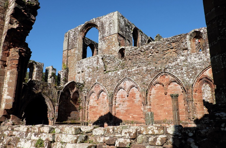
Walk 10: Furness Abbey
Bus route: 1, 2, 3, 4, 5, 6, 7 & X6 serving Barrow-in-Furness
Length/ difficulty: 8 miles; easy/moderate; approximately 3¼ hours
Map: Ordnance Survey OL6, English Lakes SW
Established in the 12th century, Furness Abbey used to be one of the richest and most powerful Cistercian monasteries in northern England, its monks controlling large areas of what we now refer to as Cumbria.
Among the striking red sandstone ruins, painted by Turner and written about by Wordsworth, are parts of the church’s east end and west tower, the cloister buildings and the chapter house.
The abbey, in the care of English Heritage and open to the public, can be reached on foot from the centre of Barrow-in-Furness. Combine your visit with a wander round the historic woodland at Abbotswood, home to several exotic species planted by James Ramsden, secretary of the Furness Railway Company and Barrow’s first mayor.
The Abbotswood mansion was built for him in the late 1850s. Return via Mill Beck and the route of the Bay Cycle Way through the docks, calling in at the fascinating Dock Museum if time allows before your bus.
Feeling inspired by Viv’s suggestions?
Check out The Lakes By Bus guide for more information and inspiration.
